The annual General Assembly of the European Geosciences Union was held in Vienna a month ago. This year three members of the WDRG were presenting, among more than 15000 other participants. I was there with a poster presentation of an R package that we have started to develop in the past months.
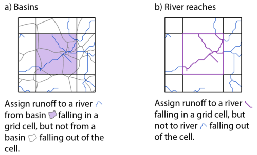
hydrostreamer is a software package which enables downscaling of (distributed) runoff products using simple spatial relationships between the areal units in the runoff product and an explicit river network (see figure 1). The aim has been to keep data requirements at a minimum, and to provide a package that is easy to use. At minimum, only two datasets are needed; spatially distributed runoff timeseries, and a river network, which both are readily available online.
The development of hydrostreamer was inspired by the realization that water availability assessments using a common field data model (raster) contains an implicit assumption that, within a specific grid cell, water is available evenly. However, in reality water tends to form streams and channels, and thus usually is available at specific locations. Our R package transforms the runoff information from field data model to a discrete object data model.

Figure 1. Downscaling in hydrostreamer can be done by the spatial relationship between input runoff data and a) river reach specific catchments, or b) river lines.
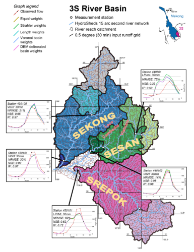
At the EGU2018 conference, we also showcased the package together with a small case study of the 3S basin in Southeast Asia, demonstrating its capabilities. We took modelled runoff from 12 different global hydrological or land surface models (available from the Inter-Sectoral Impact Model Intercomparison Project, ISIMIP), and HydroSheds river network at 15 arc second (~500 meter) resolution. The results in Figure 2 show that, when compared to observed streamflow, the downscaling approach works reasonably well in at some measurement stations, while is poor at others.
There are considerable uncertainties in the approach from two main sources. First, there are uncertainties in the input runoff data. In our 3S case, we used global modelled runoff at 0.5o degree (~55km at equator) resolution. The coarse aggregation of runoff data means that any details of higher resolution are lost. Different models contain different levels of uncertainty in their parameters and in their runoff generation processes. Secondly, the spatial relationship between stream network and the runoff products are uncertain. If the stream network and drainage basins are generated from a digital elevation model, the relationship is dictated by the quality of the elevation model.

Figure 2. Results of the 3S test case. The graphs show the runoff products which yielded the highest Nash-Sutcliffe Efficiency, and the estimates produced by three river line weighting methods, and two different catchment delineation methods.
With the groundwork in developing a functional package done, and the initial promise shown in the 3S test case, our next step with hydrostreamer include to assess how good our approach really is by looking into the uncertainties and how they propagate. The package itself is currently published as a beta-version, and will see considerable polish and additions in the coming months. The first update to version 0.1.1. will be released in the coming weeks.
To access and follow hydrostreamer, visit https://github.com/mkkallio/hydrostreamer.
To download our EGU2018 poster, visit https://www.researchgate.net/publication/325066501.
MSc (tech.) Marko Kallio works as a DSc student in both Water and Development and Geoinformatics Research Groups.
Uusi työkalu parantamaan vesimallien erotustarkkuutta
Vuosittainen Euroopan Geotieteiden Seuran vuosikokous (ja konferenssi) järjestettiin viime kuussa Wienissä. Paikalla oli kolme osanottajaa Vesi- ja kehitys tutkimusryhmästä omilla esityksillään. Omassani esittelimme kehittelemäämme R pakettia, jolla voidaan tuottaa korkean resoluution informaatiota karkean resoluution valumadatasta yksinkertaisten maantieteellisten suhteiden perusteella.
R paketin kehitystyö lähti liikkeelle ajatuksesta, että rasterimuotoinen kenttäperustainen pintaveden saatavuusarviointi ei ole tyydyttävä tapa. Vedellä on luonnossa taipumus esiintyä jokina, järvinä ja lampina eikä tasaisena kaiken peittävänä pintana kuten rasteriesitystapa antaisi olettaa. hydrostreamer on R paketti joka mahdollistaa sekä valumatiedon esitystavan muuttamisen kentistä olioiksi (jokiviivoiksi), sekä samalla tuottaa tarkemman erotuskyvyn arvioita veden määrästä eri paikoissa (ks. kuva 1).
Viime kuun konferenssissa posterimme esitteli sekä itse pakettia, että pientä sovellusta sen toiminnasta. Testasimme hydrostreameria 12 eri globaalin mallin tuottamaa valumadatan ja HydroSHEDS-jokiverkoston avulla Mekong-in 3S-sivujoissa (kuva 2). Alustavat tulokset ovat lupaavia, sillä ilman mallien optimointiakin, useimmilla mittausasemilla tekniikkamme tuottamat arviot virtaamista ovat realistisia.
Tekniikan kehitystyö keskittyy tällä hetkellä arvioimaan epävarmuuksia jotka liittyvät mallin käyttämiin lähtödatoihin (simuloitu valuma) sekä käytettyn jokiverkoston ja valumadatan maantieteelliseen suhteeseen. Lisäksi tällä hetkellä betaversiona julkaistua pakettia jatkokehitetään.
Listätietoja hydrostreamerista löytyy GitHubista: https://github.com/mkkallio/hydrostreamer.
Konferenssiposterin voi puolestaan ladata osoitteesta https://www.researchgate.net/publication/325066501.
DI Marko Kallio työskentelee väitöskirjatutkijana sekä Vesi ja kehitys- että Geoinformatiikan tutkimusryhmässä.

