Water is a crucial element not only for life itself, but our society is based on the availability of sufficient clean water resources. Unfortunately, the availability of clean, safe water is not self-evident. In addition to physical shortage of fresh water, for instance, missing or broken infrastructure, ownership issues, poverty or pollution of water resources may hinder access to it. Water poverty, lack of sufficient safe water to cover basic needs, can therefore manifest itself in multiple ways.

Water and Development Research Group, in co-operation with Geoinformatics Research Group, conducted a study investigating how water poverty is distributed in Laos spatially as well as between the distinct monsoon dry and wet seasons. Water Poverty Index (WPI) was developed and computed for 8215 villages across the country. WPI is a multidimensional composite index, which is an ensemble of five components covering different dimensions of water poverty, ranging from physical water availability to the management capacity of the villages.
As WPI is a composite index, weighting of the components is an important issue, because the weights signify the importance of each component to overall water poverty. In this study, a number of ‘objective’ weighting schemes were analytically derived based on variances and Principal Component Analysis (PCA). In addition to the weighting, the method allows to identify the main factors (i.e. principal components) controlling water poverty in Laos. Country-wide analysis gives information about the general trends in the processes, however, according to commonly known principle in geography, spatial phenomena are rarely stationary. The local differences in processes governing water poverty were therefore investigated using Geographically Weighted PCA (GWPCA), a variant of PCA which can be used to address spatial non-stationarity.
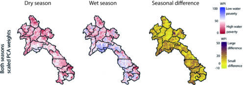
It was found that water poverty in Laos is high in the rural, mountainous areas along Vietnamese and Chinese border regions, whereas regions near the Mekong River bordering Thailand show the least water poverty. This is in line with previous studies in neighbouring countries. Three key themes were identified from the processes explaining majority of water poverty in Laos: socio-economic factors (poverty), whether villages primarily practise commercial or subsistence agriculture, and the physical location of the village. Local analysis resulted in similar processes as the global (country-wide) analysis, however it also uncovered locally important ‘hidden’ processes that were not significant nationally.

Figure 1. Water Poverty Index for both dry and wet seasons, and their seasonal difference. A high WPI score represents low water poverty where as a low score represents high water poverty.
In addition to producing the WPI dataset for Laos, the study resulted in recommendations concerning investigation of WPI components (and composite indices in general):
 performing PCA on WPI components and interpreting them as processes provides useful insights in to the causes of water poverty,
- GWPCA should be used when local differences are of special interest, and
- weights, as they were calculated in this study, can be used to summarize and help analysing the very large amount of data GWPCA produces. This methodology provides useful information for decision makers who seek to address issues related to water and poverty.
The study was published in Social Indicators Research, and can be accessed via https://doi.org/10.1007/s11205-017-1819-6. MSc (tech.) Marko Kallio works as a DSc student in both Water and Development and Geoinformatics Research Groups.
Mikä aiheuttaa vesiköyhyyttä Laosissa?
Vesi on elintärkeä elementti paitsi elämälle, myös rakentamallemme yhteiskunnalle. Riittävä puhdas vesi ei kuitenkaan ole itsestäänselvyys, vaan sen puute voi ilmetä monilla eri tavoilla. Puhdasta ja turvallista vettä ei välttämättä ole fyysisesti saatavilla, sen käytön esteenä voi olla hallinnolliset tai omistajuuteen liittyvät ongelmat, tai esimerkiksi köyhyys voi estää sen hankinnan.
Vesi ja kehitys- ja Geoinformatiikan  tutkimusryhmien yhteistyönä tehdyssä tutkimuksessa laskettiin vesiköyhyysindeksi (VKI) 8215 kylälle Kaakkois-Aasian Laosissa. Tutkimuksessa vertailtiin eri tapoja painottaa analyyttisesti VKI:n viittä eri komponenttia varianssin, pääkomponenttianalyysin, ja sen maantieteellisesti painotetun variantin avulla. Pääkomponentteja tulkittiin vesiköyhyyttä selittävinä prosesseina.
Analyysista nousi vahvasti esiin kolme teemaa; vesiköyhyyttä selittivät parhaiten sosio-ekonomiset seikat, kylienpääasiallinen talousmuoto (kaupallinen/omavaraistalous), sekä kylien fyysinen sijainti. Paikallisessa analyysissa nousi esiin alueellisesti tärkeitä prosesseja jotka eivät olleet niin vahvoja, että olisivat tulleet esille koko maan kattavassa analyysissa. Molemmat analyysit antoivat kuitenkin samansuuntaisia tuloksia vesiköyhyyden alueellisessa jakautumisessa jakautumisessa; vesiköyhyys oli suhteellisesti pienintä lähellä Mekong-jokea ja se kasvoi kohti vuoristoisia ja harvaanasuttuja alueita lähellä Vietnamin ja Kiinan rajaa.
Tutkimus osoitti pääkomponenttianalyysin hyödyllisyyden VKI:n komponenttien analysoinnissa – menetelmä voi tuottaa uusia oivalluksia sekä maanlaajuisesti että paikallisesti käytettynä. Käytetyt menetelmät soveltuvat hyvin hyödyllisen informaation luomiseen vesiköyhyyteen liittyvien päätösten tueksi.
Tutkimus julkaistiin joulukuussa 2017 Social Indicators Research-tiedejulkaisussa, ja on saatavilla seuraavasta osoitteesta: https://doi.org/10.1007/s11205-017-1819-6. DI Marko Kallio työskentelee väitöskirjatutkijana sekä Vesi ja kehitys- että Geoinformatiikan tutkimusryhmässä.

